


Southampton: Ordnance Survey takes mapping to Mars

Using NASA open data, Southampton-based Ordnance Survey has created a one-off paper and digital map of the Martian landscape. It has produced the Mars map to see if Ordnance Survey mapping has potential use for future Mars missions.
David Henderson, OS director of products, explained: “The private sector and space agencies are currently in competition to land the first person on Mars. Becoming more familiar with space is something that interests us all and the opportunity to apply our innovative cartography and mapping tradecraft to a different planet was something we couldn’t resist.
"We were asked to map an area of Mars in an OS style because our maps are easy to understand and present a compelling visualisation, and because of this we can envisage their usefulness in planning missions and for presenting information about missions to the public.”
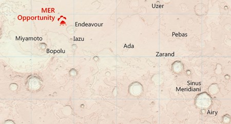
The new map covers a 3,672km by 2,721km extent of the Mars surface and has been produced to a scale of one to four million. OS cartographic design consultant, Chris Wesson, who designed the map, said: “We have set out from the start to treat the Mars data no differently from how we would treat OS data for Britain or for any other earth-based geography.
"Even though the principles are the same, the design and the aesthetics of an Earth map differ considerably. The OS cartographic style is something that is very different to your typical planetary map. The key ingredients to this style are the soft-colour palette of the base, combined with the traditional map features such as contours and grid lines, and the map sheet layout complete with legend.”
The depth and breadth of data OS produces and manages has no equal or equivalent anywhere in the world. It is used by governments, companies and individuals in keeping the nation, economy and infrastructure moving. It is data so big, yet simultaneously so granular and accurate, that the location of every fixed physical object in Great Britain, from the ground upwards, is registered. The database of Great Britain thus covers up to 500 million unique geographic features. The huge database OS maintains is kept fresh by a team of 270 surveyors and aircraft which produce more than 10,000 updates to the system each day.
This year OS celebrates 225 years of delivering the most accurate portrait of Great Britain, but the addition of the Mars map to its 607 paper maps of Britain is a giant step for the organisation. It last created a map beyond the British shores in the mid-1990s.