
Hampshire firm helps in production of 3D images of Titanic

The world’s most famous shipwreck has been revealed as never seen before – and a Hampshire firm played a part in obtaining the images.
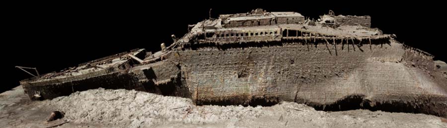
The first full-sized digital scan of the Titanic, which lies 3,800m (12,500ft) down in the Atlantic, has been created using deep-sea mapping.
It provides a unique 3D view of the entire ship, enabling it to be seen as if the water has been drained away.
Read more: India's coastal tsunami detection network being upgraded by Hampshire's Sonardyne
The hope is that this will shed new light on exactly what happened to the liner, which sank in 1912.
The 3D model is the first step in finding out exactly what happened to the Titanic. While the liner has been extensively explored since the wreck was discovered in 1985 cameras were only able to produce murky snapshots – while the 3D model reveals the wreck in its entirety.
The scan was carried out in summer 2022 by Magellan Ltd, a deep-sea mapping company, and Atlantic Productions, who are making a documentary about the project.
Submersibles belonging to OceanGate Inc, which were remotely controlled by a team on board a specialist ship, spent more than 200 hours surveying the length and breadth of the wreck.
They took more than 700,000 images from every angle, creating an exact 3D reconstruction.
Read more: Hampshire’s Sonardyne joins underwater acoustic communication project
And the Ranger2 USBL acoustic positioning system by Farnborough-based Sonardyne – which works in the oil and gas, renewables, defence, and science sectors – allowed OceanGate to track the submersible and communicate with the dive crew via text messages as they reached the wreckage.
"Having reliable communications and tracking is essential to our mission and we are grateful to have the Ranger2 system on board," said Oceangate.